Post by db on Sep 10th, 2011 at 9:11pm
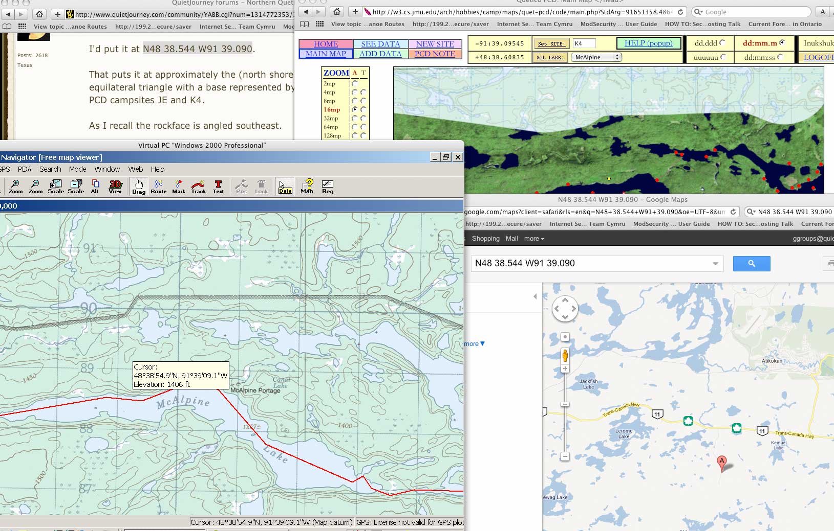
I'm sorry. I thought I added an attachment to my first post.
 gps.jpg ( 240 KB | 0
Downloads )
gps.jpg ( 240 KB | 0
Downloads )
gps.jpg ( 240 KB | 0
Downloads )| QuietJourney Forums | |
|
Boundary Waters / Quetico Discussion Forums >> Strictly Gear - Gear specific reviews and ideas. >> GPS coordinate confusion
https://quietjourney.com/community/YABB.cgi?num=1315591254 Message started by db on Sep 9th, 2011 at 6:00pm |
|
|
Title: GPS coordinate confusion Post by db on Sep 9th, 2011 at 6:00pm
So DD gives me a verbal description for a spot that I can understand. Close enough. Thanks BTW.
He also gives me GPS coordinates that I decided to try and look up. Issues I encountered: 1- First I try Google Maps - it marks half way to Atikokan from where it should be. 2- The PCD yellow dot puts it too far north (I assume). 3- Memory Maps puts it even farther north. The curser doesn't show but the reading is from essentially the upper left corner. So I grab my GPS and check things I've marked in previous years. The three I tried were all right on in Memory Map. My question is, what an I missing or doing wrong for 1,2 or 3 above? I believe my topo is NAD83. That matter? If so how? I'll accept any clues anyone wants to provide. |
|
Title: Re: GPS coordinate confusion Post by DentonDoc on Sep 9th, 2011 at 7:53pm db wrote on Sep 9th, 2011 at 6:00pm:
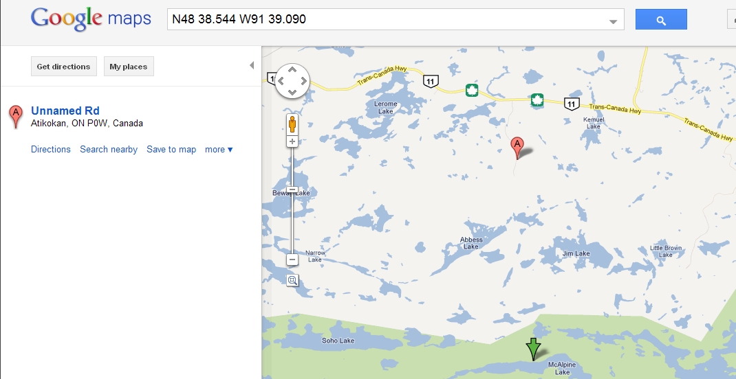
It could be just a difference in format (although I use WGS 84 ... which might produce a very small difference in location). What I originally posted was in a "decimal minutes" format. Here is the same location expressed in degrees-minutes-seconds format: N48 38 32.6 W91 39 05.4 as a UTM reference, it would be: 15 U 599336 5388582 I've checked on Google Maps and it does (eventually) provide the correct location. All I can surmise is that Google Maps is "city-centric." It gives the location of the nearest incorporated area. So, try this (for google maps). Enter the original coordinates provided in the google tool bar (which was N48 38.544 W91 39.090). It will show an initial arrow head near Atikokan and a coordinate position of +48° 42' 31.85", -91° 39' 34.83". (Note: this is NOT the position initially provided.) Go ahead and click on the map segment provided ... it will indeed show a red pin head located in the presumed position with the letter "A" on it. Now, re-paste the original coordinates (as in, NO! I REALLY mean that spot). It will not relocate to the new location, but if you scroll down to McAlpine lake there will be a green arrow head at the correct spot.) You can also get the same result if you re-search once the map is on the screen. This is not exactly good map making, IMHO! I'll try the PCD and Memory Maps to see why you got your results, but when I created a wayppoint and edited the location (cut/paste) to show the spot, it was dead on in MM (so I suspect a format/conversion difference there). dd |
|
Title: Re: GPS coordinate confusion Post by DentonDoc on Sep 9th, 2011 at 8:26pm db wrote on Sep 9th, 2011 at 6:00pm:
I re-checked. The PCD yellow dot is north (on shore) of the picto location (but that's where my GPS marked it at the time ... slightly on shore; north, maybe 60 feet). When I took the reading, it was a quick mark and go ... I didn't put the unit into "location averaging" which would likely be a bit more accurate. dd |
|
Title: Re: GPS coordinate confusion Post by db on Sep 9th, 2011 at 9:00pm
I appreciate it DD. FWIW - I'm not playing around. I know you guys know this stuff and use it. I just expect it to be simple math with a rounding error of (what?) 20 feet or so no matter the format offered? I'm wondering if there is some sort of variable I'm missing so I can curse at it while I try to understand it's purpose and allow for it. :D
|
|
Title: Re: GPS coordinate confusion Post by db on Sep 9th, 2011 at 9:09pm
Ohh! I see the green Google arrow now. That's close enough I guess.
|
|
Title: Re: GPS coordinate confusion Post by db on Sep 9th, 2011 at 9:16pm
We could not calculate directions between 53005 and 48.642389, -91.651500. ;D
|
|
Title: Re: GPS coordinate confusion Post by wally on Sep 10th, 2011 at 12:09pm
dam GPS formats! It;s like VHS vs Betamax.
|
|
Title: Re: GPS coordinate confusion Post by Marten on Sep 10th, 2011 at 2:49pm
In some instances where the GPS waypoints show up 30-100 yards off on the map, it is the map that is wrong. No one could tell until the GPS came along. This summer I was in an area of WCPP where this happened. The trail I marked would show up starting 100 meters out in the water when viewed on the map screen.
This is why a GPS option is to set it on "lock on road." It corrects and puts you on the road and not off to the side. In actual use on the trail, if you are using the same datum as the person who marked the waypoint it should put you really close. |
|
Title: Re: GPS coordinate confusion Post by Mk631 on Sep 10th, 2011 at 6:24pm db wrote on Sep 9th, 2011 at 9:09pm:
So the conclusion is that there's no GPS issue ... Just a problem w/how Google decides to put the mark on a road rather than where you tell it to go. But the green arrow goes in the real spot. Right? |
|
Title: Re: GPS coordinate confusion Post by db on Sep 10th, 2011 at 8:57pm
Ummmmmmmm no.
I have/see a problem I want to understand. Google was the control - or so I thought. A generic, ubiquitous constant I thought I could go/point to and I now get that part. The green arrow is close enough I expect but what I really wanted (expected) was something repeatable, for everyone no matter.... It's math. Words depend on what you bring to them but this is math. There's only ten numbers and who knows how many words and counting. With math, translations should be easy - to the point where someone says close enough. Both have commas to catch your breath but math should be exact until you lose interest after the decimal. IMO. We have pictures now. Is the math that subjective? |
|
Title: Re: GPS coordinate confusion Post by db on Sep 10th, 2011 at 9:11pm
I'm sorry. I thought I added an attachment to my first post.
gps.jpg ( 240 KB | 0
Downloads ) |
|
Title: Re: GPS coordinate confusion Post by azalea on Sep 11th, 2011 at 7:17pm
What were the GPS coordinates given. Could it be a format issue: fractional degrees vs fractional minutes vs fractional seconds?
|
|
Title: Re: GPS coordinate confusion Post by db on Sep 12th, 2011 at 4:52am
I was looking at:
"I'd put it at N48 38.544 W91 39.090." And I assume that's a period at the end. The picture I posted shows the radio button format I used for the PCD. I get where Marten is coming from too and that seems plausible but between the topos and the aerials and places I've marked before in Q, I expect this stuff to be rather exact so I can only assume I'm doing something dopey and perhaps easy to correct. Don't want to form any bad habits due to ignorance. |
|
Title: Re: GPS coordinate confusion Post by db on Sep 12th, 2011 at 4:57am |
|
Title: Re: GPS coordinate confusion Post by Mk631 on Sep 12th, 2011 at 9:00pm
I think the problem belongs entirely to Google -- The green arrow is the actual spot. But the "A" spot is where they zoom in because it's the closest road they can find, so they put you there zoomed in so tight you can't see the green arrow until you zoom out (4 "-" zoom clicks).
All coords are on roads, right? ;D {rant mode on} What's Google thinking-- you don't have to be a wilderness canoeist or hiker or anything like that to want to see points that aren't on roads!!! {rant mode off} -Tom PS: Another way to examine this Google oddity is to (when in Google maps) right click & choose "What's Here?" in an area not very near a road -- you get a green arrow where you clicked, and an "A" mark at something it can understand better - usually (but not always) a road... Goofy_Google.jpg ( 225 KB | 0
Downloads ) |
|
QuietJourney Forums » Powered by YaBB 2.6.0! YaBB Forum Software © 2000-2026. All Rights Reserved. |