| QuietJourney Forums | |
|
Boundary Waters / Quetico Discussion Forums >> General Boundary Waters / Quetico Discussion >> Kashapiwi portage update
https://quietjourney.com/community/YABB.cgi?num=1431134482 Message started by Nanda on May 9th, 2015 at 1:21am |
|
|
Title: Kashapiwi portage update Post by Nanda on May 9th, 2015 at 1:21am
Hey folks,
I just returned from my first solo trip from Bayley Bay into Kashapiwi. I am pulling together a trip report but thought that I'd give everyone an update on this portage as well as others in the area that I used. The portage into Kash from the Side Lake direction is different from how it's depicted on the McKenzie map. It's actually split in two as opposed to one long route on the map: one very short portage of 2 or 3 rods located on your right. The trail climbs up about 10-15ft from the lake going over a granite bald-face rock ledge and then the trail disappears into the water of the swamp. I was forced to put the boat back in, reload and paddle into the swamp for about 30 yards or so. The next section is again on the right and hidden back into the swamp. I found it by looking for where the forest descended into the swamp (the trail is right there). This trail climbs a short 10 to 15 ft again into the woods, continues for maybe 10 rods or so and then descends into a boot-sucking bog. Don't step of the barely-visible corduroy logs laid out or you may sink in up to your upper-thigh...as I found out. The bog trot continues for about 20 or 30 rods until it rejoins the forest. From there it's a straight shot to Kash. I looped out via the McNeice portage to Shaun Walshe, Yum Yum, Grey, etc. eventually rejoining my way in via North Bay. Most of the portages have at least some or alot of 12-16 inch blowdowns and deadfall. These are probably typical for this park or any park for early May. The portage crews obviously have not been through this area yet. On my way out, I found the maintenance crew at the PP ranger cabin setting it up. They flew out the next morning in the direction of Cache. Anyway, I hope that this information helps if anyone is going in that way soon. |
|
Title: Re: Kashapiwi portage update Post by solotripper on May 9th, 2015 at 1:20pm
Thanks Nanda,
I'm heading into park May 14th. Should be going thru that same area sometime around the 23-24 of May. I navigate with McKenzie's, but use a Chrismar to double check portage locations in unfamiliar areas. From the Chrismar Adventure Quetico map 2014 edition, it shows 2 portages as well and the new Paddle Planner site does as well. From Side you found the portages to be on the right. Both maps I referenced showed the 1ST one out of Side being on the LEFT heading North. They do differ on the portage location at end of no-name lake. Any chance that because it's a well used route there might be more than a few portage trails on BOTH ends? I'm going to print out your report and IF I have the time, I'll see IF there are alternate trails or the maps just differ for whatever reason? |
|
Title: Re: Kashapiwi portage update Post by Nanda on May 10th, 2015 at 2:31am
solotripper,
you are correct. My map and my experience this past week as well found the first portage out of Side Lake into the No_Name Lake to be on the LEFT and only about 20 or 25 rods? long. The SECOND portage on the right now has a first short section of about 2 to 3 rods over a granite bald due to a beaver dam that is under construction and if I remember correctly, some rocks/low rapids. You have to portage up and over which is a nuisance because you then float for about 50 yards to the second part that climbs into the forest, bog trots for about 20 rods or and then rejoins the woods to continue on. I was thinking from my Chrismar and McKenzie map that I would find only ONE long portage of 184 rods on the RIGHT but instead found TWO. Anyway, let me know what you find when you get out there ;) |
|
Title: Re: Kashapiwi portage update Post by solotripper on May 10th, 2015 at 11:30am
Thanks Nanda :thumbup
I'll be sure to tell you what I find? I looked at a couple of portage reports from the QJ portage database. Does this sound accurate to you? (You need to Login or Register Some contradictions between ALL the reports but that might be becasue of the water level/beaver activity so yours is probably the latest accurate description. |
|
Title: Re: Kashapiwi portage update Post by BillConner on May 10th, 2015 at 12:16pm
Encourage the beavers. It sure would be nice to float to the base of the steeper part like the first time I went that way.
|
|
Title: Re: Kashapiwi portage update Post by solotripper on May 10th, 2015 at 2:32pm
Yup, I'd rather paddle than portage whenever possible although depending on the portage it can be a enjoyable walk in the woods.
|
|
Title: Re: Kashapiwi portage update Post by Solus on May 10th, 2015 at 10:00pm
Or paddle all the way across the marsh to the old portage on the other side of the talus pile and avoid all steep parts.
|
|
Title: Re: Kashapiwi portage update Post by HoHo on May 10th, 2015 at 11:03pm
Below is a link to a trip report for this area in 2012. For the portage from Unnamed into Kahshahpiwi, at that time the portage went all the way through form Nanda's granite bald (what I refer as a rocky outcrop) to Kahsh, but you had to take a very sharp right turn right at the top of the rocky outcrop to follow the faint path (which was only a few years old after the old beaver dam went out). I'm not sure I would have seen the path if our dog Piwi had not been in the lead, she always knows where the trail is. I'm wondering if you might have missed it, Nanda, or maybe after that turn the trail is under water from the newly forming beaver pond. And yes - it would be great to have the entire old pond back!
Here's the link - (You need to Login or Register |
|
Title: Re: Kashapiwi portage update Post by Nanda on May 10th, 2015 at 11:30pm
Interesting to piece together where/what the trail was versus what it is now from everyone's recollection! I had just paddled past a campsite on my right on the way to this. I backtracked, got out at the campsite and climbed into the woods looking for the portage trail. No luck.
So, I got back in, paddled another couple of yards and found the beaver dam/rocks and low waterf with a dirt embankment and trail on the right. I climbed it, came to the bald rock and....no trail. There wasn't even a hint of trail to the sharp right as the embankment dove steeply into the water. I calculated, as others are surmising here that the trail must be under water and put back in. I thought about paddling down the stream with the sheer granite face wall to the left (everyone remember that?) but decided against it because I had no idea where it went. This is when I backtracked again, paddled into the swamp on my left and found the trail picking up as it climbed another embankment and headed into the woods. In hindsight, it would be great if you could float past the bog section on your right, somehow take-out close to the woods, skirt that edge of the bog to the trail and continue on. The rest of the trail to Kash is in very good shape and a relatively easy walk to the lake. This current way is far more adventurous. Nearly had mud in my pockets on this one ;D |
|
Title: Re: Kashapiwi portage update Post by BillConner on May 11th, 2015 at 11:14am
I went in September of 2012 and I believe it was the year in which the "new" corduroy portage was installed on the east side of the meadows. I don't recall any problem finding it but I think the orange plastic tape markers were still in place.
It was a big improvement over a couple of years earlier when coming down the west side I lost a boot in hip deep muck. Still liked the pond and paddling the whole way the first time in early 2000s. |
|
Title: Re: Kashapiwi portage update Post by Solus on May 11th, 2015 at 1:24pm
Nanda- if the stream is navigable (you'd be going up not down) around the giant talus slope below the cliff you would reach the terminus of the old portage which is a dry relative highway to Kahsh.
I went through there last year. There was not enough water to paddle on the other side of the hump, at least not for any distance. The portage was a faint path through the marsh close to it's edge on the right (along the edge of the steep rock bank climbing into the woods). The trail went up the bank briefly before descending into the long corduroy-being-consumed-by-mud section that eventually ties into the old trail. |
|
Title: Re: Kashapiwi portage update Post by intrepid_camper on May 11th, 2015 at 3:36pm
Years ago I passed this way and at the time was unfamiliar where the portage was. I did the right hand side path and it disappeared into brush, moved downhill into the bog (at the time no corduroy) and finally I found myself in center of the bog where the walking was surprisingly good (solid) to the "back" of the dry pond where I ran into the main portage trail on high land.
Coming back later on that trip I realized the main trail comes out at the base of the cliff and talus pile. I agree with Solus that if you can get to that (talus) end of the portage at all, go that way. |
|
Title: Re: Kashapiwi portage update Post by Nanda on May 11th, 2015 at 3:47pm
Next time I'm paddling to the back of that cliff wall!
|
|
Title: Re: Kashapiwi portage update Post by Rocky on May 27th, 2015 at 7:35pm
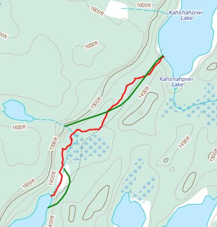
I went through there last summer. The red line in the attached picture is the GPS track.
kahs.jpg ( 62 KB | 25
Downloads ) |
|
Title: Re: Kashapiwi portage update Post by solotripper on Jun 8th, 2015 at 9:20pm
I read all the portage reports as well as Nanda's and so when I went thru I took the time to check things out and see why different reports seem to conflict?
One of my pet peeves when reading directions is when the person giving them uses the terms Left/Right instead of the N/S/E/W compass directions. One of the portage reports says that going from Side to the Un-Named lk, you want to go Left/East? If your going North, then left is West. I will give the compass directions only, assuming for the discussion that Kashahpiwi is North. From Side lk, you find the first portage easily enough. Go in woods about 50' and the trail splits West and East. I went West to see what the put-in was like? As described in a portage report the West side is a bad place to put-in, forget about it. I walked across the beaver dam and came back on the East side. You cross the stream but the put-in on the no-name is much better. The next portage is as Nanda described. It is on the East side and with the low water there was a nice sand/gravel beach to land on. Up a little hill, down a rock face and your on your way. The next part is where depending on water levels, you could get in trouble or be confused? I read about the Granite Face cliff in the NW corner and that's where I headed. Water level was so low, I had to stand up and use my double paddle like a Gondolier and push my way to rock garden landing. I did as one portage report suggested and shuttled with some difficulty my gear to flat area in cedars and easily picked up the trail to Kash. A few hundred yds in, I saw those orange trail markers and the trail to a take-out that in HIGH water would be accessible from the East side. I didn't walk down to the "new" take-out, but at the intersection of the old/new trail someone had laid some brush/logs across trail, presumably to guide people to the new landing. I would let water levels determine which spot I used going North/South because there was no way in hell I could of gotten up the East side. The "old" trail on the NW side is in good shape and the rough/dangerous landing is probably why they want to route folks around it. So its 2x East sides and depending on water levels, either the NW corner or the NE one. The Kash portage is mostly long and not that hard. I did the Yeh portage later in trip and THAT bad boy is worse than the Kash portage AND the Badwater combined IMHO. |
|
Title: Re: Kashapiwi portage update Post by Nanda on Jun 8th, 2015 at 9:31pm
Thanks Solotripper. Good information and it sounds like your route shortened the overall portage to Kahsh a bit?
|
|
Title: Re: Kashapiwi portage update Post by solotripper on Jun 8th, 2015 at 10:27pm Quote:
I don't know about shortening the route, but by taking that LEFT/RIGHT stuff out, I think it simplify's the route, or at least I hope it does. I'm a little perplexed on why the Rangers think the NEW landing on the east is going to be the best route IF they permanently block the old one out of the NW corner? IF the water level is low and you have to go thru a mud bog/corduroy to use the new landing, I'd rather go the rock garden route on the NW corner. At least you stay dry while you unload your gear. Anyway, people have the choice, because I don't think the old NW path is going away anytime soon, unless they really throw up a road block and literally force you to the new put-in-take-out. |
|
Title: Re: Kashapiwi portage update Post by Solus on Jun 11th, 2015 at 1:59pm
ST-
The "new" route on the east side (the one with the long trail over the bog) was constructed because when the beaver dam between the swamp and no name lake went out a few years ago there was no possibility of floating the stream to the old landing. It wasn't possible to use the route on the NW so they blocked the established trail so folks traveling from Kahsh wouldn't follow the more obvious trail to a bottomless muck pit bordered by a giant bolder slope. The NW route was in use the first time I traveled it in 82 until a few years ago. It is much shorter and easier. |
|
Title: Re: Kashapiwi portage update Post by solotripper on Jun 11th, 2015 at 2:17pm
Thanks Solus, that makes sense.
Good to know you have multiple options, but IF the conditions allow it, that NW landing isn't all that bad. I'd take THAT route over a bog walk any day. |
|
Title: Re: Kashapiwi portage update Post by Solus on Jun 12th, 2015 at 12:27am
Agree 100%. If you can start your carry (or finish your put in depending upon direction) near the base of that talus slope that is a somewhat long but very easy and beautiful portage.
|
|
Title: Re: Kashapiwi portage update Post by explorer165 on Jun 22nd, 2015 at 5:53pm
Thanks to all who have posted on this portage. We just returned from Quetico on Saturday June 20 but had decided to explore the West side if the water levels looked decent. From our experience the beaver dam has achieved a water level high enough to paddle up to the NW corner of the talus area. We landed fairly close to what I recall as the original take out point. The places from which you can do this are quite limited. From the take-out point we used we easily found the portage path, although it is quite overgrown. We did not encounter any need to pole our canoe perhaps due to some recent rain being added into the water pool level. We only saw a few other footprints along the portage indicating that only a few folks have passed through this year. We did not look for the East side portage so cannot verify its current condition. As long as the water levels hold up the West paddle/portage is doable.
|
|
Title: Re: Kashapiwi portage update Post by Nanda on Jun 23rd, 2015 at 2:56am
Thanks. Sounds as though the better time to reach that portage is when there has been enough rain to make it to the point you made it to. Thanks for the report!
|
|
Title: Re: Kashapiwi portage update Post by HoHo on Sep 7th, 2015 at 1:18am
We went over this portage on Thursday (9/3/15) coming out of Kahshahpiwi and the reversion to the old, western route is now complete. If you are coming from Kahsh on the portage, when you get to the junction of the old and new (west and east) routes, you will find that the "new" (east) route is now the one that is blocked off. Follow the "old" (west) route and you soon come to a put-in in the beaver meadow that has *just barely* enough water to float in, though the depth improves as you head downstream (south). At the far end of the meadow that you are floating through there is an approximately 10-rod portage over the granite outcrop on the east side of the waterway into the unnamed lake between Kahsh and Side.
The route is easy to follow if coming from the north as we were, but might be harder if coming from the south, because it would not be immediately obvious how far up the shallow waterway in the beaver meadow you should paddle to find the portage takeout. I took a GPS waypoint when we were there and will add it to this post later on when I get it downloaded. |
|
Title: Re: Kashapiwi portage update Post by portage dog on Sep 7th, 2015 at 1:30pm
FWIW, I did the east portage on August 5th. There is a fair amount of corduroy covering about half of the boggy part, but probably from heavy use, most of it was 'below surface' and hard to tell it was there. Most of the rest of the way is boot sucking muck. We paddled the last few hundred yards to the beaver dam - now about 5' high, I'd guess. Sounds like the west or talus slope route would be a bit easier/shorter.
pd |
|
Title: Re: Kashapiwi portage update Post by Solus on Sep 7th, 2015 at 2:22pm
Coming from the south it is easy to find the take out, just paddle beneath the high cliffs past the talus slope until you can't paddle anymore. Did this 8/31- the new pond is considerably deeper than the old.
|
|
Title: Re: Kashapiwi portage update Post by Nanda on Sep 8th, 2015 at 2:52am
All good news. Might be worth a return trip next Spring!
|
|
QuietJourney Forums » Powered by YaBB 2.6.0! YaBB Forum Software © 2000-2026. All Rights Reserved. |