|

|
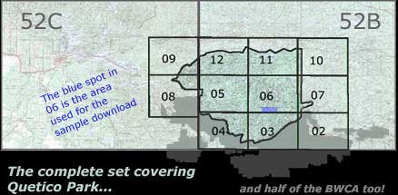
1:250,000 Scale
- 52B Quetico
- 52C International Falls
1:250 000 is convenient for general
planning or leaving general plans
with your emergency contact but
it lacks the detail needed to stay found.
The 1:50,000 is what every member
of your party should have with them
at all times.
|
|
1:50,000 Scale
- 52B02 Saganaga Lake
- 52B03 Knife Lake
- 52B04 Basswood Lake
- 52B05 Poohbah Lake
- 52B06 Kawnipi Lake
- 52B07 Mowe Lake
- 52C08 Lac La Croix
- 52C09 Pipe Lake
- 52B10 Burchell Lake
- 52B11 Pickerel Lake
- 52B12 Quetico Lake
|
|
- At the heart of this CD are the topographic maps, which are basically
.png files, ready to modify, crop and print to scale or any size you
wish using many different flavors of readily available software, one
or two of which you probably already have on your computer. Digital
topographic maps don't get more versatile than this!
- High quality, raster images in PNG format. (raster = resolution
dependent. Size matters.)
- Printable to scale at 150 dpi
- Print maps just like the regular printed topos you can buy or your
printer allows.
- All topos are geo-referenced and Pre calibrated for use with software
packages including Memory-Map,
OziExplorer,
Fugawi and MacGPS
Pro
- Produced under license from Her Majesty the Queen in right of Canada,
with permission of Natural Resources Canada.
-
Free Viewer included! (Windows ONLY) Map
capture#1 - Map
capture #2 - Map capture
#3
Featuring simple navigation; you can plot waypoints and routes,
measure time/distance... Put the mouse cursor anywhere on the map
and a block indicates position in Long/Lat or UTM... at that point.
Easy to install and use, the free Memory-Map viewer software
is included on the CD! (Windows 98, Me, NT,
2000 or XP required. Not compatible with Windows 95, pre-Pentium
processors or Macintosh. Optional GPS integration, Garman, Navman,
Magellan... requires your unit outputs the NMEA 0183 "RMC"
sentence.)
Please note: This is a demo "viewer" for
Memory-Map. You cannot print from the demo nor will it interface
with any GPS unit unless you purchase a license. Please follow the
links for the software manufactures above. Most offer demos, all
give prices.
View the list of all topographic
maps included on the CD.
|


